Aqueduct in Kavala, Greece. 25 meters height and a total of 60 arches. It was built in AD 1530 on a Roman model during the reign of Süleyman the Magnificent. The Aqueduct still serves today as a symbol of the city.
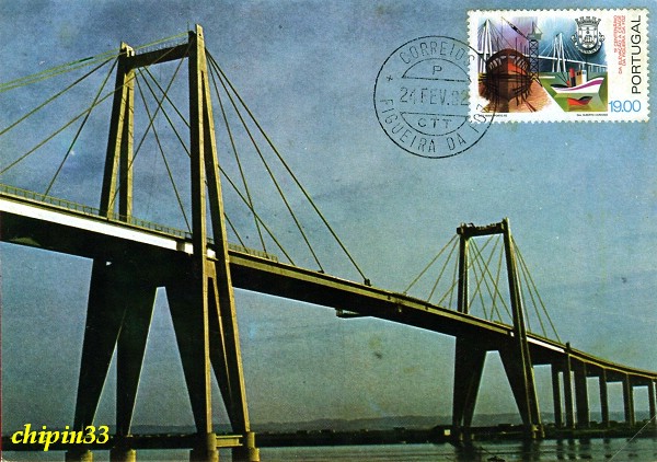
Figueira da Foz Bridge spanning the River Mondego in Figueira da Foz city of the district of Coimbra, in Portugal. It has a total length of 1421 m, in-cluding a 405 m long cable stayed bridge and two approach viaducts with 630 m (left bank) and 315 m (right bank).
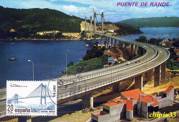
Rande Bridge (Puente de Rande) is a cable-stayed bridge built in 1978 that links the strips of land of the Strait of Rande on the ria of Vigo. It has a length of 1,558 metres, its pillars have a height of 148 metres and its main span measures 401 metres. Although it was not the biggest (cable-stayed) span in the world when it opened, it was the longest span with more than two lanes. The bridge, which links Redondela and Moaña through the Strait of Rande, is one of the world's longest bridges. It is currently the longest in Spain and it is an emblematic piece of engineering in the ria of Vigo.
Puente Viejo (Old Balmaseda Bridge), whose name means "old bridge" in Spanish, is the older and smaller of two bridges that span the 120 m deep chasm that divides the city of Ronda in southern Spain. It was over the River Kadagua and built in 12th century; the larger, newer Puente Nuevo was built in 1751.
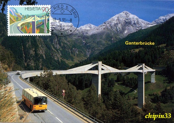
Ganter Bridge rises an astonishing 152.4 meters above the ground. The 160 meter long bridge designed by Menn. Built 1976-1980 over the Simplon Pass near Eisten, Switzerland, is a concrete cable-stayed road bridge. The Ganter Bridge is hybrid cross of construction combining cantilever and cabling support system. Cantilever spands support the bridge's midsections which in turn are supported by cable stays embedded in prestressed concrete. The concrete walls protect the cables from stress and corrosion. Menn cleverly embedded the cable stays in prestressed concrete resulting in a bridge that appears to be a sculptured bird taking flight.
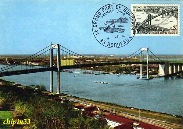
Aquitaine Bridge (Pont d'Aquitaine) is France's second largest suspension bridge spanning the Garonne, north-west of the city of Bordeaux. It forms part of the ring-road of Bordeaux and carries the A630 autoroute. It was completed in 1967 and it has 1757 meters in length and the main span is 394 meters long. Its effective road surface is 20 meters wide and is suspended 53 meters above the river.
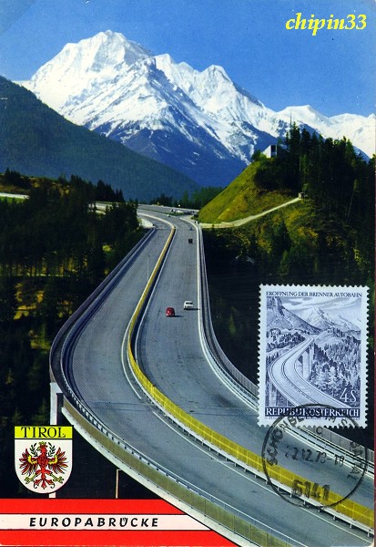
Europabrücke, or Europe's bridge, is a 777 meters long bridge spanning the 657 meters Wipp valley just south of Innsbruck, Tirol, Austria. The A13 Brenner Autobahn (and European route E45) passes over this bridge, above the Sill River, forming part of the main route from western Austria to Italy via South Tirol across the Alps. It is also part of the main route between southeastern Germany and northern Italy. The longest span between pillars is 198 meters built between 1959 and 1963, it was once Europe's highest bridge, standing 192 meters high above the ground, until it was topped out by France's Millau Viaduct on 14 December 2004.
Brenta Bridge (Ponte Degli Alpini) is a wooden covered bridge on the Brenta River in Bassano del Grappa, Italy. It was designed in 1569 by the architect Andrea Palladio to replace a pre-existing construction existing at least from 1209. The bridge is a symbol of the Bassano del Grappa town. It was destroyed many times, the last time during WWII. The Alpine soldiers or Alpini have always revered the wooden bridge and Bassano del Grappa. After the destruction of the bridge, they took up a private collection and had the bridge completely rebuilt. Often soldiers flock to the bridge to remember and sing songs from their days as alpine soldiers. The grappa shop of Nardini Distillery is located on the bridge, also known as Ponte Vecchio (Old Bridge).
Adolphe Bridge is a stone arch bridge in Luxembourg City, in southern Grand Duchy of Luxembourg. It has become an unofficial national symbol of sorts, representing Luxembourg's independence, and has become one of Luxembourg City's main tourist attractions. The bridge 153 meters long features a large double arch with a span of 85 meters overhanging the Pétrusse valley 42 meters below. With a width of 17.2 meters, the bridge is connected via 4 communication lines with 3 of them connecting to train stations, and the other going to Ville Haute bus line, accompanied by 2 pedestrian walkways. Adolphe Bridge was built between 1900 and 1903. Although it is now over 100 years old, it is also known as the New Bridge by people from Luxembourg City. The “old bridge” in this comparison is the footbridge, which was built between 1859 and 1861.
Peace Bridge is an international bridge between Canada and the United States at the east end of Lake Erie at the mouth of the Niagara River, about 20 kilometres upriver of Niagara Falls. It connects the City of Buffalo, New York and the Town of Fort Erie, Ontario. It is operated and maintained by the Buffalo and Fort Erie Public Bridge Authority. The Peace Bridge consists of five arched spans over the Niagara River and a Parker through-truss span over the Black Rock Canal on the American side of the river. The total length is 1,768 m. Material used in the construction included 1,067 m of steelwork, 9,000 tons of structural steel and 800 tons of reinforcing steel in the concrete abutments. The Peace Bridge was named to commemorate 100 years of peace between the United States and Canada. It was constructed as a highway bridge to address the needs of pedestrian and motor vehicle traffic which could not be accommodated on the International Railway Bridge, built in 1873.
Stone Bridge (Pont de pierre) is an old bridge located in Bordeaux, in the Gironde department of France, which crosses Garonne River to connect cours Victor Hugo on the left and Avenue Thiers on the right. As the first bridge over the Garonne River at Bordeaux, it was constructed from 1819 to 1822, during which the builders were faced with many challenges because of the strong current at that point in the river. They used a diving bell borrowed from the British to stabilize the bridge's pillars. The bridge is 487 meters long and has a total of seventeen arches, which correspond to the number of letters in the name of Napoléon Bonaparte. It was the only bridge until the construction of pont Saint-Jean in 1965.
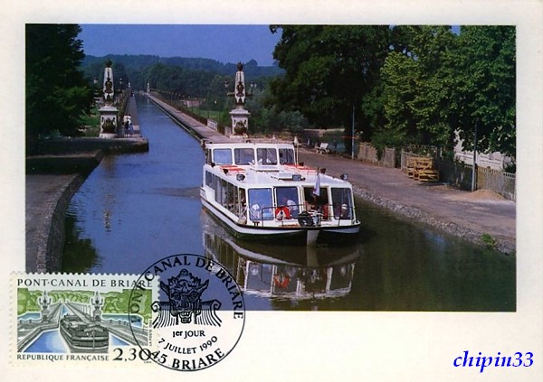
Briare Canal Bridge (Pont-canal de Briare) is a metal girder canal bridge, built with the help of the engineer Gustave Eiffel. It is the longest canal bridge in Europe (662.7 meters). It allows both barges and pleasure boats to cross the Loire River and to pass from the left minor canal to the Briare canal. Built from 1890 to 1894, it was opened in 1896. In the late 19th century, this was a major transportation route for commodities and it was an architectural prowess to make such a bridge at that time.
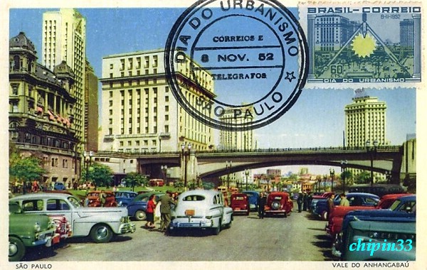
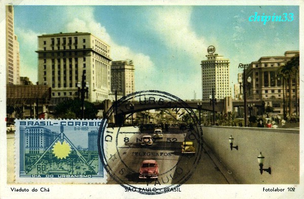
The overpass cross downtown streets in São Paulo. São Paulo is the capital of the state of São Paulo, Brazil. The city is the largest in Brazil and first in South America by population. It is located in the South East of the country. It is also the richest city of Brazil. The name means Saint Paul in Portuguese. The city has an area of 1,523 square kilometres and a population of 10,886,518, which makes it the most populous in Brazil, in South America and in the southern hemisphere. Greater São Paulo, which includes adjacent municipalities, has a population close to 20 million, making it the second largest in the Americas, and one of the largest metropolitan areas in the world.
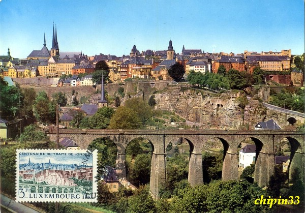
The Passerelle, also known as the Luxembourg Viaduct, is a viaduct in Luxembourg City, in southern Luxembourg. It runs southwards from the city centre, Ville Haute, carrying road traffic across the Pétrusse valley and connecting Boulevard Franklin Delano Roosevelt to Avenue de la Gare. It is 290m long, with 24 arches, and 45m above the valley floor. It is also known as the Old Bridge (Luxembourgish: Al Bréck, French: Vieux pont, German: Alte Brücke) by people from Luxembourg City. The 'new bridge' in this comparison is the Adolphe Bridge, which was built between 1900 and 1903. The Passerelle was built between 1859 and 1861 to connect the city centre with Luxembourg's new railway station, which was located away from the city centre so as to not detract from the defensive capabilities of the city's fortress.
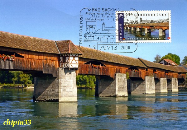
Bad Säckingen Covered Bridge (Old Rhine Bridge) that links Bad Säckingen in Germany with Stein Aargau in Switzerland. It is the longest covered bridge main structure at just over 200 m in Germany, Switzerland and possibly in Europe. It is also Germanys southernmost covered bridge and probably has some of the oldest timbers still in use in a bridge. The bridge belongs to the German town of Bad Säckingen, but it crosses the border into Switzerland at the deepest part of the river. It has been restored many times and used to carry motor vehicles - now it is a pedestrian footbridge.
Many thanks Mrs. Kalpana Sharma mail above two beautiful bridge maximum cards of newest Joint issue Germany/Switzerland to me from Germany.
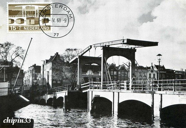
Magere Brug ("Skinny Bridge") is a bridge spanning the River Amstel in the city centre of Amsterdam. It connects the banks of the river at Kerkstraat street, between Keizersgracht canal and Prinsengracht canal. The Magere Brug is a bascule bridge made of white painted wood. It was built in 1934. The first bridge at this site was built in 1691 as Kerkstraatbrug and had 13 passes. Because this bridge was very small, the locals called it Magere brug, which means small or skinny bridge. In 1871 the state of the bridge was so bad that it was demolished en replaced by a wooden bridge with nine passes. Fifty years later this bridge also needed to be replaced. Architect P.L. Kramer made a few designs of steel and stone, but the city decided to replace the bridge with a new bridge that looked the same as the last one, only slightly bigger. In 1934 the bridge was demolished and replaced. The last major renovation was done in 1969. Until 1994 the bridge was opened by hand, now it's opened automatically. Since 2003, only pedestrians and cyclists are allowed to use the bridge. Many times a day it is opened in order to let ships pass; the boats used for sightseeing tours are low enough to pass underneath the bridge when closed. The bridge is decorated with 1200 light bulbs that are turned on in the evening.
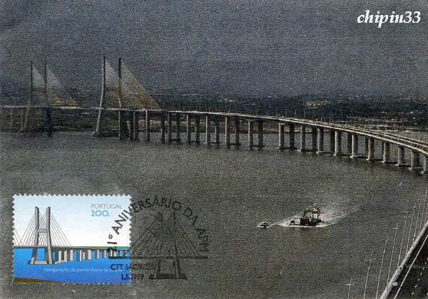
Vasco da Gama Bridge (Ponte Vasco da Gama) is a cable-stayed bridge flanked by viaducts and roads that spans the Tagus River near Lisbon, capital of Portugal. It is the longest bridge in Europe (including viaducts), with a total length of 17.2 km, including 0.829 km for the main bridge, 11.5 km in viaducts, and 4.8 km in dedicated access roads. Its purpose is to alleviate the congestion on Lisbon's other bridge (25 de Abril Bridge), and to join previously unconnected motorways radiating from Lisbon. The bridge was opened to traffic on March 29, 1998, 18 months after construction first began, just in time for Expo 98, the World's Fair that celebrated the 500th anniversary of the discovery by Vasco da Gama of the sea route from Europe to India.
A Maximum card is made up of three elements: 1. The postage stamp. 2. The picture postcard. 3. The postmark. 1+2+3=maximum card The maximum cards should conform to the principles of maximum possible concordance between.